The Solutions Explorer lets you create alerts that match your needs. You can create several alerts and you will receive a notification each time a new Solar Impulse Efficient Solutions is labelled and matches your filters.
Your Search Alerts will show up here.
Sign in to create alerts for your filters and search terms.
Sign inDon't have an account?
Sign upAccess exclusive opportunities for Investor Members Only
The Investment Hub is a platform by the Solar Impulse Foundation that connects innovators with investors to fund scalable and sustainable solutions. Through tailored matchmaking, e-pitches, and a collaborative digital environment, it helps drive impactful innovation forward.
Sign in to explore a world of dynamic and high-potential investment opportunities.
Sign inDon't have an account?
Sign upFebruary 2, 2020
International Portal of Prague
Prague
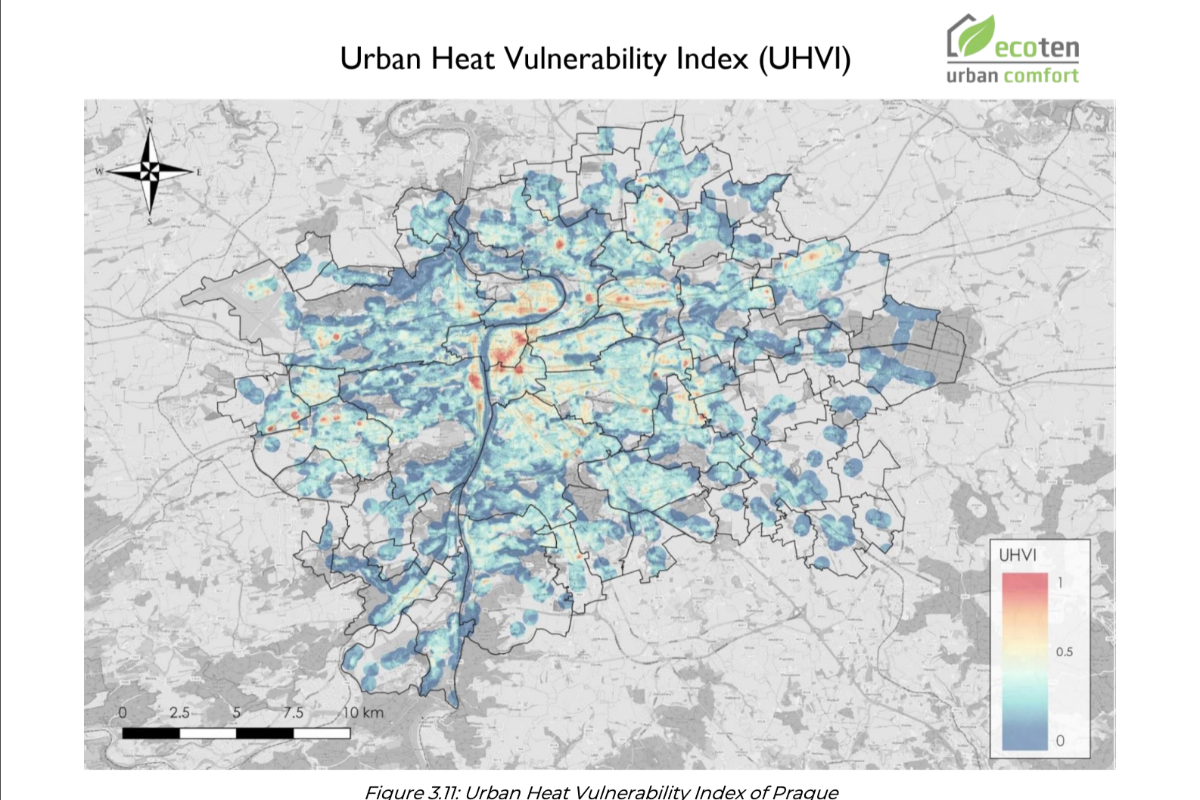
The case study presented in the report focuses on assessing the urban heat vulnerability of public transport stops in Prague, Czech Republic, conducted by ECOTEN Urban Comfort. The study aims to map and analyze the vulnerability to extreme heat in Prague using a framework from the Intergovernmental Panel on Climate Change (IPCC), including exposure, sensitivity, and adaptive capacity. - Exposure measures the prevalence of high temperatures, or hot spots, using satellite data. - Sensitivity assesses how vulnerable people are to heat based on factors like age and health. - Adaptive Capacity evaluates the city's ability to cope with heat, considering green spaces and water bodies. The urban heat vulnerability index (UHVI) for Prague was calculated by combining these components, and the results were used to rank the city's senate districts. The study aims to guide urban planners in identifying the most heat-resilient areas and prioritize those needing attention for heat resilience improvements, particularly around public transport stops. The report also suggests adaptation measures for these areas to enhance the quality of life in Prague.
Improved urban microclimate and reduced heat island effect in areas with increased green and blue-green infrastructure, leading to cooler temperatures at public transport stops and surrounding districts. Enhanced resilience to heat reduces potential costs related to infrastructure damage and public health expenses by identifying and prioritizing areas for targeted intervention, guiding efficient use of resources in urban planning.
The Urban Heat Vulnerability Map is processing 3 times more data sets and is delivered 4 times quicker than the traditional approach, empowering cities to identify the most vulnerable areas to extreme heat events and therefore maximise the impact of the implementation of heat mitigation strategies.
Share
The information set out above, is solely for the purposes of information and the Solar Impulse Foundation does not provide any guarantee as to its authenticity, completeness or accuracy. This information does not constitute investment advice or a recommendation to buy into, transact or to enter into any agreement with any of the parties or persons mentioned above. Potential investors or interested parties are solely responsible for their investment or business decisions and for performing any due diligence required by the circumstances. The innovator has asserted ownership of the intellectual property rights for images, videos, and content showcased above, affirming full and unrestricted usage rights, and has provided explicit permission for the Solar Impulse Foundation to publish such information designated as "public" in the application form.