The Solutions Explorer lets you create alerts that match your needs. You can create several alerts and you will receive a notification each time a new Solar Impulse Efficient Solutions is labelled and matches your filters.
Your Search Alerts will show up here.
Sign in to create alerts for your filters and search terms.
Sign inDon't have an account?
Sign upAccess exclusive opportunities for Investor Members Only
The Investment Hub is a platform by the Solar Impulse Foundation that connects innovators with investors to fund scalable and sustainable solutions. Through tailored matchmaking, e-pitches, and a collaborative digital environment, it helps drive impactful innovation forward.
Sign in to explore a world of dynamic and high-potential investment opportunities.
Sign inDon't have an account?
Sign upDecember 1, 2023
Forestry Cooperative
Sologne region (South of Orléans)
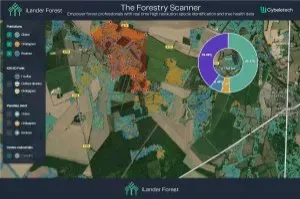
The solution is used in the Sologne region in France, by a major forestry cooperative. The cooperative's area of interest is 5 500 km², and they are interested in the identification of oak, chestnut and birch trees. They provided a small set of sample data, and the software produced a map of the entire area of interest, showing the distribution of the species of interest in their entire area. The solution generated significant savings in time and fuel for the customer, as they would otherwise have to collect the information manually.
To obtain the same coverage and detail of data, it is estimated that each square kilometre would have to be crossed twice by car to be able to collect the information on the trees = 11,000 km covered for the Sologne region. To have up-to-date information, they would have to repeat the data collection every three years, whereas the solution does not require new data collection at all.
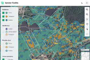
Ilander-Forest is a forestry management tool, providing precise and up to date information on forest content to forestry professionals. The solution relies on the analysis of satellite images to determine automatically the location and distribution of tree species in the forest, and to monitor tree health. Cybeletech has created this tool to provide forestry experts with all the necessary data for informed decision making in forest management, including early tree-health deterioration alerts to ensure a quick response to the hazard.
Share
The information set out above, is solely for the purposes of information and the Solar Impulse Foundation does not provide any guarantee as to its authenticity, completeness or accuracy. This information does not constitute investment advice or a recommendation to buy into, transact or to enter into any agreement with any of the parties or persons mentioned above. Potential investors or interested parties are solely responsible for their investment or business decisions and for performing any due diligence required by the circumstances. The innovator has asserted ownership of the intellectual property rights for images, videos, and content showcased above, affirming full and unrestricted usage rights, and has provided explicit permission for the Solar Impulse Foundation to publish such information designated as "public" in the application form.